Site and Environment
Critical Areas Designation (CADS25-0076)
King County completed a Critical Areas Designation for the primary parcel (3624079039) in July 2025. The full report is not available through King County’s online permit portal. Download it here. Here’s what they found:
| Critical Area | Location | Buffer | Building Setback |
|---|---|---|---|
| Steep Slope Hazard | Eastern portion (10–55 ft vertical rise) | 50 ft | +15 ft |
| Category III Wetland | Northeast corner (habitat score 7) | 150 ft (high-impact) | +15 ft |
| Type F Aquatic Area (Fisher Creek) | Northwest portion, fish habitat | 115 ft | +15 ft |
| Unmapped Floodplain | Associated with Fisher Creek | Requires Floodplain Development Application |
King County classified the project as high-impact under KCC 21A.24.325A.2.a, the designation that triggers the widest buffers.
Updated riparian buffers (February 2026)
King County’s Critical Areas Ordinance was amended by Ordinance 20024, adopted December 15, 2025 and effective February 18, 2026. The new ordinance designates riparian areas as their own critical area category and significantly increases buffer widths.
For Type F streams (like Fisher Creek) in the Urban Growth Area, the riparian area width is now 180 feet from the ordinary high water mark, up from the prior 100-165 foot range. Where the riparian area overlaps with a steep slope or landslide hazard area, the buffer extends to the top of that hazard, capped at twice the base width: 360 feet maximum.
Fisher Creek runs along the project’s northern boundary where steep slope hazard polygons are mapped. That overlap triggers the extended protection.
This matters because the Critical Areas Designation for this site was completed in July 2025, before Ordinance 20024 took effect. Any site planning Jupiter Power conducted under the prior buffer standards is outdated. The applicant must use the current riparian area widths, which further constrain the buildable footprint.
Why this matters
Fisher Creek is a Type F stream. It has fish. It runs through the northwest portion of the parcel, and the elevation difference between its ordinary high water mark and the proposed development area is less than 10 feet. If there’s a fire, runoff contaminated with heavy metals and fluoride compounds goes straight into the creek and from there into the Snoqualmie River watershed.
Jupiter Power also has to file a separate Floodplain Development Application before they can even apply for a development permit. That’s a gating requirement they haven’t started yet.
Between the steep slopes on the east, the wetland buffer on the northeast, and Fisher Creek on the northwest, the buildable footprint is a lot smaller than “45 acres” makes it sound.
The wildlife picture is incomplete. The CAD report identified two large hollow trees or snags where Vaux’s swifts could nest, and noted that western toad may use the site. But Jupiter Power isn’t the property owner, so they couldn’t get the full sensitive species PHS report from WDFW. The ecologists worked with partial data.
Visual screening
Critical area buffers will preserve vegetation on the north and east sides. But the west side, facing the backyards of homes on Bracken Place SE and SE Center Street, has no buffer protection at all. There’s nothing in any public document committing Jupiter Power to keeping the existing trees or adding screening on that side.
Wildlife and habitat
ESA-listed species
Fisher Creek flows into the Snoqualmie River, which supports three species listed as threatened under the federal Endangered Species Act:
| Species | ESA Status | Listed |
|---|---|---|
| Puget Sound Chinook salmon | Threatened | 1999 |
| Puget Sound steelhead | Threatened | 2007 |
| Bull trout | Threatened | 1999 |
Chinook populations in the Snoqualmie watershed have declined to approximately 10% of historic levels. The Snoqualmie Watershed Forum, a partnership including the Snoqualmie Tribe, Tulalip Tribes, King County, and the cities of North Bend, Snoqualmie, Carnation, and Duvall, has allocated over $13.3 million to 270 habitat restoration projects since 1998. The Snoqualmie Tribe’s Environmental and Natural Resources Department is actively working to restore riparian habitat along the Snoqualmie River.
Contaminated fire suppression runoff from a lithium-ion BESS fire would drain from Fisher Creek directly into this watershed. The creek is less than 10 feet below the proposed development area.
On-site species
The Critical Areas Designation identified two large hollow trees or snags where Vaux’s swifts could nest. Vaux’s swift is a WDFW Priority Species whose populations have declined an estimated 50% since the late 1960s, primarily from loss of old-growth nesting habitat. The CAD also noted that western toad may use the site.
Both findings came with a caveat: Jupiter Power is not the property owner, so the ecologists could not access the full WDFW Priority Habitats and Species (PHS) report. The wildlife assessment was done with partial data. A full biological assessment has not been conducted.
What a full EIS would require
If SEPA review produces a Determination of Significance, the resulting Environmental Impact Statement would require a complete biological assessment of the site, including species surveys conducted during appropriate seasons. If there is a federal nexus (federal funding, federal permits, or federal land), ESA Section 7 consultation with NOAA Fisheries (for salmon and steelhead) and US Fish and Wildlife Service (for bull trout) could be triggered. No such assessment or consultation has been initiated.
Private wells and groundwater
Recorded well on a project parcel
A Declaration of Covenant — Private Water Supply (Recording #199810141781, October 1998) documents an active domestic well on parcel 3624079100, one of Jupiter Power’s five project parcels. The well is located 360 feet east of the west property line and 165 feet south of the north property line.
The covenant establishes a 100-foot exclusion zone around the well, prohibiting cesspools, sewers, septic tanks, drainfields, storm water facilities, and public roads. Sanitary and abandoned landfills are prohibited within 1,000 feet. The covenant runs with the land and binds all future owners as long as the well supplies potable water.
Dozens of domestic wells surround the site
The WA Department of Ecology well log database shows 58 water wells in Section 36, T24N, R7E (the section containing the project parcels). The residential area downhill to the southwest has the highest concentration: 31 water wells in the SW quarter alone.
| Quarter Section | Water Wells | Depth Range | Average Depth |
|---|---|---|---|
| NW (project area) | 9 | 152-460 ft | 280 ft |
| NE | 3 | 88-393 ft | 214 ft |
| SW (downhill residential) | 31 | 23-421 ft | 191 ft |
| SE | 12 | 59-435 ft | 227 ft |
The nearest well with recorded water level data is on SE 89th Place, close to the project parcels: 255 feet deep with a static water level at 216 feet below ground.
Adjacent property owner Deborah Bellam (8620 356th Ave SE) is on private wells with no city water connection.
Why this matters
Contaminated runoff from a lithium-ion battery fire (heavy metals, fluoride compounds, electrolyte) could migrate through soil to groundwater. At Moss Landing, researchers estimated 55,000 pounds of toxic metals entered surrounding wetlands, with nickel concentrations in nearby soil spiking to 15 times pre-fire levels. Groundwater contamination from fire suppression water is a documented pathway at BESS fire sites.
No hydrogeologic assessment has been submitted for the Cascadia Ridge project. Groundwater flow direction, aquifer connectivity, and contaminant migration pathways to the surrounding domestic wells are unknown.
Sumner precedent
When the City of Sumner reviewed a 200 MW BESS with a public water well on the project parcel, the well drove the three most aggressive MDNS conditions in any Washington BESS project:
- Site plans must show the well, its protective radius, and all public water infrastructure
- Property within the well protective radius must be deeded to the city with security fencing
- Hydrogeologic assessment required before development permits
The city stated that even a driveway within the well’s sanitary control area was “unacceptable.”
Cascadia Ridge has a recorded well covenant on a project parcel, plus dozens of domestic wells in the surrounding area. The factual basis for demanding well protection conditions is at least as strong as Sumner’s.
Historical well logs
Three sets of historical well logs in the Ecology database contain subsurface geology data for the project area that has not been analyzed:
- AESI wells (1998) near 372nd Pl SE: four records contemporaneous with the well covenant on parcel 9100, likely related to the same investigation. Three water wells (160-220 ft) and one abandoned (200 ft).
- Weyerhaeuser monitoring wells (2000) in the NW quarter: two resource protection wells (170 ft, 260 ft) and three abandoned wells, drilled during Snoqualmie Ridge development.
- Cascadia Ridge soil borings (January 2026) on parcel 9103: six records filed under “Cascadia Ridge,” three shallow borings (16-25 ft) with paired decommissioning records. These are geotechnical borings, not groundwater exploration. No water level data was recorded.
The actual driller’s logs (which describe soil layers, water-bearing zones, and aquifer characteristics) are available as scanned documents through the Ecology well report viewer. Navigate to Section 36, T24N, R7E to access them.
Seismic hazard
The Snoqualmie Valley sits in one of the most seismically active regions in the continental United States. Three independent earthquake sources threaten this site:
- Deep intraslab earthquakes (like the 2001 Nisqually quake): 85% chance of M6.5+ in the Puget Sound region in the next 50 years
- Crustal fault earthquakes (Southern Whidbey Island Fault, mapped through the valley; Seattle Fault): 17% chance of M6.5+ in the next 50 years
- Cascadia Subduction Zone megathrust: 10-15% chance of an approximately M9 earthquake in the next 50 years
These probabilities come from USGS Fact Sheet 2025-3050 (Wirth et al., “Earthquake Probabilities and Hazards in the U.S. Pacific Northwest,” September 2025).
No site-specific seismic hazard assessment has been submitted for the Cascadia Ridge project. No published study exists on how utility-scale BESS facilities perform during seismic events. King County’s ordinance requires IEEE 693 seismic qualification for equipment mounting, but that standard does not address the full failure chain: earthquake damages cells, thermal runaway ignites, toxic emissions spread through a valley prone to atmospheric inversions, and contaminated fire suppression runoff drains into Fisher Creek.
Parcels and land deals
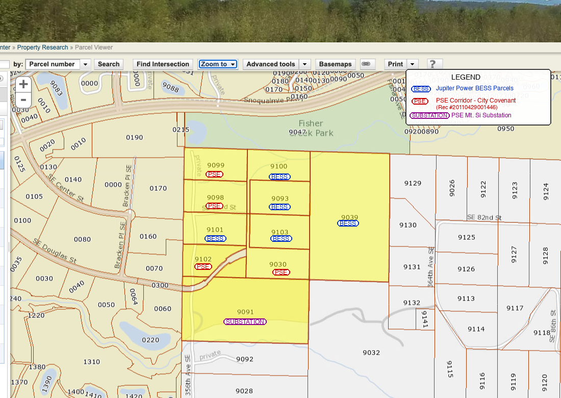
Jupiter Power has recorded purchase or option agreements on five parcels totaling approximately 45 acres. All agreements were found through the King County Recorder’s Office and are public record.
| Parcel | Acres | Owner | Zoning | Jupiter Power Deal |
|---|---|---|---|---|
| 3624079039 | ~25.4 | Snoqualmie 55 LLC | UR | Purchase agreement (Jan 2024), 5-year due diligence |
| 3624079093 | ~5.0 | Nause LLC | UR | Option to purchase (Mar 2024). Vacant, transmission line easement. Not in original permit application. |
| 3624079101 | ~5.0 | Landgraf | UR | Option to purchase (Jul 2025), 5-year term |
| 3624079100 | ~5.0 | Nause LLC | UR | Memorandum recorded Aug 2025 |
| 3624079103 | ~5.0 | Arnold | UR | Memorandum recorded Nov 2025 |
| Total | ~45 |
Adjacent: PSE transmission corridor (~19.5 ac, parcels 3624079030, 3624079098, 3624079099, 3624079102).
Jupiter Power’s project entity is Cascadia Ridge Resiliency LLC, a Delaware LLC registered to 1108 Lavaca St, Austin, TX. The entity was originally formed as “Snoqualmie Energy Storage LLC” in December 2023 (with Accelergen Development LLC as sole member) and renamed in June 2025. The 2024 land agreements were recorded under the original name; the 2025 agreements use the current name.
Parcel 3624079093 is notable: it’s a 5-acre vacant lot with a transmission line easement, owned by the same Nause LLC that owns the adjacent parcel 3624079100. Jupiter Power secured an option on it the same day they signed the main purchase agreement (March 4, 2024), but it was not listed in the original permit application. It may be intended for access, buffer, or additional infrastructure.
The Snoqualmie Indian Tribe owns a nearby parcel (3624079104, ~15.8 ac) but it is not adjacent to the project parcels and has no recorded Jupiter Power agreement.
Construction access
There are two potential road access routes to the project parcels, neither designed for industrial construction traffic. One runs through the PSE transmission corridor (all five PSE corridor parcels), where the PADA and Covenant impose restrictions limiting use to transmission line operations. The other follows a private residential road east through Short Plat 775062 parcels to 364th Ave SE, using a road easement referenced in parcel 9039’s legal description. The scope of that easement, and whether it permits construction traffic for a 130 MW battery storage facility, depends on the terms of the original instrument. See the full analysis on the recorded documents page.